Seismic Zones of India
IS 1893 (Part 1) : 2016 — Criteria for Earthquake Resistant Design
Understanding Seismic Zones of India
India lies in one of the world’s most seismically active regions. IS 1893 classifies the entire country into four seismic zones based on historical earthquake damage surveys, tectonic features, and lithological characteristics. Each zone carries specific design implications for structural engineers.
The Four Seismic Zones
IS 1893 (Part 1) : 2016, Clause 6.4.1 states: “For the purpose of determining design seismic force, the country is classified into four seismic zones as shown in Fig. 1.” India originally had five zones (I–V), but Zone I was merged into Zone II in the 2002 revision. Today, zones are numbered II through V — with Zone II being the least severe and Zone V the most.
Zone II
The lowest hazard zone in India. Corresponds to Low Seismicity. Structures here must still be designed for earthquake loads, but the lateral forces are relatively mild. Many parts of the Deccan Plateau, Rajasthan and the southern peninsula fall here.
Zone III
Moderate Seismicity. A large portion of peninsular India, the western coast, Gangetic plains, and most of Maharashtra fall here. Standard ductile detailing (IS 13920) is strongly recommended. Cities like Mumbai, Chennai and Ahmedabad are in this zone.
Zone IV
Severe Seismicity. Includes the Indo-Gangetic plains, parts of Himalayan foothills, most of J&K (except high Himalayas), Bihar, and coastal Andhra. Delhi falls in this zone. Ductile detailing IS 13920 is mandatory for RC structures.
Zone V
Very Severe / Highest Hazard. The entire Northeast India, Kashmir valley (Srinagar), Himachal Pradesh (parts), Kutch region (Bhuj). This zone has witnessed some of India’s most destructive earthquakes (1897 Shillong, 1934 Bihar, 2001 Bhuj).
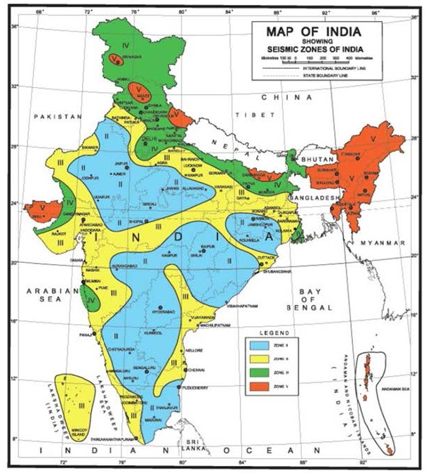
Seismic Zone Map — Fig. 1
The Seismic Zone Map (Fig. 1) of IS 1893 is based on past earthquake damage records, tectonic features (Annex B) and lithology (Annex C). Below is a schematic representation of India’s seismic zone regions with key cities marked. For regulatory/official use, always refer to the actual Fig. 1 of IS 1893 (Part 1) : 2016.
Zone Classification Guide
Design Horizontal Seismic Coefficient (Ah)
Once you know the zone, the fundamental task is computing Ah — the design horizontal acceleration coefficient. This dimensionless factor, when multiplied by the weight of the structure, gives the design lateral force. Everything begins with the Zone Factor Z.
Design Horizontal Acceleration Coefficient
Table 3: Seismic Zone Factors (IS 1893 Cl. 6.4.2)
| Seismic Zone | Zone Factor (Z) | Z/2 (DBE level) | % of g (as PGA) | MSK Intensity | Hazard Level |
|---|---|---|---|---|---|
| Zone II | 0.10 | 0.05 | 10% g | MSK VI or less | Low |
| Zone III | 0.16 | 0.08 | 16% g | MSK VII | Moderate |
| Zone IV | 0.24 | 0.12 | 24% g | MSK VIII | Severe |
| Zone V | 0.36 | 0.18 | 36% g | MSK IX & above | Very Severe |
Design Coefficient Calculator — Ah
Use this interactive calculator to compute the design horizontal seismic coefficient Ah for any location in India. All inputs are as per IS 1893 (Part 1) : 2016.
Seismic Design Coefficient Calculator
IS 1893 (Part 1) : 2016, Clause 6.4.2 — Ah = (Z/2) × (I/R) × (Sa/g)
MSK 1964 Intensity Scale — Zone Correlation
The Seismic Zone Map is broadly associated with the 1964 MSK Intensity Scale (Annex D of IS 1893). Each seismic zone corresponds to an expected maximum intensity of ground shaking. The MSK scale describes shaking in terms of human perception, structural damage, and geotechnical effects — rated I to XII.
Zone II — Frightening
Felt by most indoors and outdoors. Minor non-structural damage to Type A (brick/earthen) buildings. Dishes may break. No structural collapse. Buildings remain fully functional.
Zone III — Damage of Buildings
Most people run outdoors. Damage Grade 2 to Type B buildings (ordinary brick). Most Type A structures suffer Grade 3 damage. Large bells ring. Some structural cracks visible.
Zone IV — Destruction of Buildings
Most Type B buildings suffer Grade 3 damage. Type A structures badly damaged. Monuments and chimneys overturn. Ground cracks up to several cm wide. Serious structural damage expected.
Zone V — General Damage
Many RC buildings suffer Grade 3 damage. Most Type A/B structures collapse. Railway lines bend. Underground pipes break. Widespread liquefaction risk. Landscape permanently altered.
Damage Classification in MSK Scale (Annex D)
| Grade | Description | Structural Indication | Appears in Zone |
|---|---|---|---|
| Grade 1 | Slight Damage | Fine cracks in plaster, small plaster pieces fall | Zone II+ |
| Grade 2 | Moderate Damage | Small cracks in walls, chimney parts fall, pantiles slip | Zone III+ |
| Grade 3 | Heavy Damage | Large deep wall cracks, chimneys fall | Zone IV+ |
| Grade 4 | Destruction | Gaps in walls, partial building collapse, inner walls collapse | Zone V |
| Grade 5 | Total Collapse | Complete collapse of the building | Zone V (severe) |
Seismic Zone Finder — Indian Cities
Annex E of IS 1893 (Part 1) : 2016 provides the seismic zone and zone factor Z for towns with population over 3 lakhs (Census 2011). Search below or browse all cities:
Soil Classification for Spectral Design
The Sa/g value (spectral acceleration) depends critically on the soil type. Softer soils amplify earthquake waves and have longer plateau periods. IS 1893 classifies soils into three types for this purpose (Table 4), based on the weighted average Standard Penetration Test (SPT) N-value from ground level to 30m depth.
Rock or Hard Soils
Includes well-graded gravel (GW), well-graded sand (SW), poorly-graded sand or clayey sand (SP/SC) with N > 30, and stiff-to-hard clays with N > 30. Lowest seismic amplification — response spectrum plateaus soonest.
Medium or Stiff Soils
Poorly-graded sands (SP) with little fines having 10 ≤ N ≤ 30, stiff-to-medium fine-grained soils (ML, CL) with 10 ≤ N ≤ 30. Moderate amplification. Plateau extends to 0.55s.
Soft Soils
All soft soils other than SP with N < 10. Includes high-compressibility silts (MH), high-compressibility clays (CH), and silty-clay combinations. Highest amplification — plateau extends to 0.67s.
What Each Zone Means — Design Implications
Understanding the zone is just the first step. Each zone carries specific design and detailing obligations under IS 1893 and companion codes. Here’s what changes as you move from Zone II to Zone V:
🏗️ Ductile Detailing (IS 13920)
🔩 Foundation Tie Beams
🧱 RC Wall Plan Density (ρw)
🏔️ Vertical EQ Effects (Cl 6.3.3)
📊 Design Base Shear ratio
🔄 Bearing Pressure Increase
Key Takeaways
Zone = Starting Point
The seismic zone (from Fig. 1) defines Z — the single most critical input for seismic design. Everything downstream (Ah, VB, detailing) depends on it.
Z reflects MCE, not DBE
Z is the Maximum Considered Earthquake level. Dividing by 2 gives the Design Basis Earthquake (DBE) level used for force calculation.
Higher Zone = More Detailing
In Zones IV and V, ductile detailing (IS 13920) is mandatory. More robust detailing ensures the structure can absorb energy inelastically without collapse.
Soil Amplifies Shaking
Soft soils (Type III) attract higher spectral acceleration (Sa/g) at longer periods. The zone factor Z is the same, but the structural demand is amplified by the soil.
Boundary = Higher Zone
When a town falls on the boundary between two zones, IS 1893 mandates adopting the higher (more severe) zone for design. When in doubt, be conservative.
Site-Specific Studies
Critical structures (nuclear plants, large dams) require site-specific hazard assessment even if IS 1893’s zone provisions are taken as the minimum.
Generate Project Submission Report
Fill in your project details and compute the seismic design coefficient. The tool will generate a formatted report card you can use in project submissions.
📄 Seismic Design Report Generator
IS 1893 (Part 1) : 2016 — Design Horizontal Seismic Coefficient Report